GPS Discussion Group

   / GPS Discussion Group
  • Thread Starter
#21  
Derek,

I did download the Expert Version and do like it. It does give me everything I pretty much want. AS far as the state map it never asked me that so until I do some more digging into it I am not sure if I got any map at all or how to open any of them. I probably will run my thrity days out before I get back to it.

I am also looking at some of the maps that Garmin makes and they also will give me what I want. I spend $60.00 for Expert or $110.00 for the Garmin Map that I think would give me more than 'Expert????

Got any suggestions I would appreciate it.
murph
 
   / GPS Discussion Group #22  
I'm at work now, I don't have ExpertGPS in front of me. I have never used the garmin software. When I looked at the software about 4 years ago I felt it was to expensive and did as much as the Delorme 3D topoquads that I purchased at that time. If you are just uploading and dowloading waypoints, routes and tracks the ExpertGPS is the better way to go. They are the USGS maps. Plus with ExpertGPS you can look at aerial photos with your waypoints, routes or trackes loaded on to them, just like the topomaps. I think it is a neat feature but not a needed feature. Also with ExpertGPS you can down load maps for all 50 states. You can also (might be for a small fee) down load something like 1.6 million waypoints (points of interest for all 50 states) along with a description of the points. Again a neat feature but not a need feature. Just my thoughts.

One thing you may consider if you do a lot of work with tracks rather than routes is get a GPS with memory. I know my Magellan Meridian Platinum can use removable media card up to 128MB. So you can track a section of road or trail and save the track to the card. That way you can build a log of you tracks you need and not have to deal with the extra track information or the dead reconing, turn off a GPS unit in one place and turning it on in another.

Hope this helps and does /forums/images/graemlins/confused.gif
 
   / GPS Discussion Group
  • Thread Starter
#23  
Derek,

I have a Garmin Etrex Vista. I mostly use it for 4 wheelin up north which is mostly woods. You can lost pretty easy. One feature I liked with one of the programs that I was trying was the fact that I could draw lines on where I was over an aerial view. As far as extra memory I am not so sure I would need that as I think I have 24 meg built in already. I looked into an extra memory chip and could not find one for my GPS. However, I can run for three days in the woods with my wheeler and still only use of about 40% of my track log. With the mud and all we don't get too far in a days time. If lucky we get 20 miles a day.

I still am wondering about how to open the state that you were talking about?

murph
 
   / GPS Discussion Group
  • Thread Starter
#24  
Rowski,

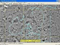
I did some more research on the ExpertGPS and made some maps. To save the map as a .jpg file you can not do. You have to do a "Print Screen" and then paste it in a photo editor of some kind. Attached is three maps I made of a 4 wheelin trip. All three maps are of the same area and trip. One map is from ExpertGPS and two are from USAPhotomaps.

First one is ExpertGPS, I had to scrunch them all down to get under the 150 limit here but you can see what I did.

murph
 

Attachments

  • 261848-screen3.jpg
    261848-screen3.jpg
    92.2 KB · Views: 83
   / GPS Discussion Group
  • Thread Starter
#25  
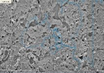
pic 2 is from worldmaphotos
 

Attachments

  • 261850-Screen1.jpg
    261850-Screen1.jpg
    96.9 KB · Views: 84
   / GPS Discussion Group
  • Thread Starter
#26  
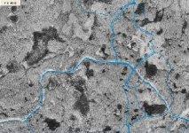
tis picture is the same as the last one but only zoomed in. You can see where I actually drove over the same trail a couple of times.

These are aerial views from world maps. The blue line is actually the trail I drove on. You can take the lines off and see the roads leading back into the trails that I went on. It is pretty accurate as the line gets put right on the roads.

murph
 

Attachments

  • 261853-Screen2.jpg
    261853-Screen2.jpg
    93.4 KB · Views: 84
   / GPS Discussion Group
  • Thread Starter
#27  
I had to downsize the maps to get under the 100k limit. The first map using ExpertGPS allows me to name the waypoints. That is what is in the white boxes.

World maps only will display the waypoints when you scroll over with your mouse. Otherwise it only shows a green dot that is very tough to see. Shrinking the file made the green dots not noticeable.

I think I will purchase the ExpertGPS. I still wonder about opening the states though. I can't find how to do that or if you can download them to your GPS.

Murph
 
   / GPS Discussion Group #28  
Opening the state is done when you download. I just mentioned incase you used your Gps out of your home state. In other words the Minnesota maps are the only map you can veiw till you pay then you can veiw all 50 states.

I haven't tried printing yet, but the way you explained it make sense.

</font><font color="blue" class="small">( One feature I liked with one of the programs that I was trying was the fact that I could draw lines on where I was over an aerial view. )</font>

I'm not sure what you mean. You can draw "lines" in ExpertGps. As far as I have found you can't draw free hand but if you make the "legs" when you draw it looks almost like free hand. Once you have drawn a "route" say over your track you can save the route. Then when the time comes you can upload the route as a track or a route to your GPS. Hope that made sense /forums/images/graemlins/confused.gif. Not sure if you found the online manual for ExpertGPS. But it explains the tools fairly well.

I'm still on my trial period too. I will purchase it too. Seem like a nice bang for the buck. I hope to play with ExpertGPS a lot in the next week or so before spring chores start. I won't have to much time then.
 
   / GPS Discussion Group
  • Thread Starter
#29  
Derek,

I guess what I mean with the lines is I can overlay my tracks on the aerial view. I didn't mean to confuse you. As far as the state, when I did my download it never ask me a state or anything it just downloaded the exe file and that was it. Did I downlaod or install wrong??

murph
 
   / GPS Discussion Group #30  
murph

Maybe I downloaded or installed something wrong /forums/images/graemlins/frown.gif. Hope the program works out for you. If you run into something give me a shout and I'll do the same.


Looks like there is a lot of water around where you go 4 wheel'n.

Best of luck
 

Tractor & Equipment Auctions

2008 Ford F450 (A49461)
2008 Ford F450...
2005 Sterling Acterra Tender Truck (A51039)
2005 Sterling...
2007 Pace American Enclosed Trailer (A49461)
2007 Pace American...
2006 Ford Crown Victoria Sedan (A50324)
2006 Ford Crown...
2014 PETERSON 4700B HORIZONTAL GRINDER (A51242)
2014 PETERSON...
JOHN DEERE 5205 TRACTOR (A51406)
JOHN DEERE 5205...
 
Top