OP
dodge man
Super Star Member
Surveyors say GIS stands for get it surveyed.
It happens. The subdivision where our family camp is was done in the 1950's. Somewhere around 1975 it was determined that the first pin was set about 17 feet to far to the north, thereby making every lot corner in the 25+ lot subdivision about 17 feet to the north. In another case a former employer sold the corner lot of a much larger parcel which abutted two roads. When it was carved out the surveyor used the wrong road r/w width so had to go back and fix it. The problem was that on his second attempt he added 17 feet as he left the road; then tacked it on again at the far end, so that the corner was that much too long. Since he never closed his survey I picked up on it when connecting the two back pins with a hand compass, but at the point they decided not to pursue it.I'm familiar with a parcel of land along a river that was subdivided into about a dozen lots all about the same size (average 100' wide and 350' deep)...I was here when the original survey laying out the lots was done and know exactly where the original corner pins are...
On a few occasions where one or more of the lots changed hands and a new survey was done...the new surveys never once agreed with where the original pins should be...some would be different by nearly 3'...
It's a good idea IN THEORY. But your out the money if the purchase falls through.<snip>
When a person buys a house or piece of property, it is most likely the largest investment they will make in their life. Why not get it surveyed BEFORE you buy it? <snip>


That certain parcel of land, with the buildings and improvements thereon, situated in the Town of _____ , County of ________, State of Rhode Island, bounded and described as follows:
NORTHERLY partly on a highway known as _____ Road, partly by land now or formerly of [Person 1] and partly by land now or formerly of [Person 2].
EASTERLY on ____ Brook.
SOUTHERLY by land now or formerly of [Person 3].
WESTERLY partly by said [Person 3] land and partly by land now or formerly of [Person 4].
Containing approximately __ acres. Be all said measurements more or less, or however otherwise the same may be bounded or described.
Surveyors say GIS stands for get it surveyed.
That's where a surveyor shows that his career is an art as well as a science. My deed is very similar. If the lines weren't well defined by fences, lines of occupation as well capped surveyor's pins on one side and partway up the back- or if I was going to be doing anything near them- I would have had it surveyed long ago.I have a survey question. I bought a piece of land in 2006, the entire legal description of the property in the deed reads as follows (identifying information redacted):
Looking at online genealogy records, I've been able to establish that:
Person 1 lived 1848-1928.
Person 3 lived 1830-1920.
Person 4 lived 1829-1908.
I believe this description was recorded around 1875 when the property was mortgaged for the first time. The property was acquired in 1683 by a family that owned it until 1950, passing only through inheritance.
Is there any point to a survey with a description this vague? Property lines are marked by stone walls, I have aerial photos from the 1930's showing the location of the stone walls, they haven't moved.
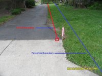
As a land surveyor it痴 not like I知 the only one that can use a tape measure or GPS or total station. There is nothing wrong with a person trying to find their corners or measure up their property. It can also be a problem if your wrong. Kind of a little knowledge can be dangerous.
A person above mentioned getting GPS coordinates on their corners. How? There is a big difference between consumer grade and survey grade GPS. If this is just so you can get close to spot the corners. Thatç—´ fine. Just figure consumer GPS can be off 30 feet in open skies and worse in trees.
There is also all sorts of coordinate systems. Surveyors rarely work in lat and longs.
There are times counting buggy wheel revolutions may be at odds with GPS findings.
I'll finish by saying there are times you need to get a surveyor and a lawyer involved. In my 34 plus years of surveying, 26 years of it licensed, I've seen a few cases where a person was truly getting screwed. In one case a person had been to court and was being pressured to settle a case even though he was right. He couldn't afford a survey or a lawyer. I ended up doing a $2000 survey for $500. In another case I did the work for free. I'm lucky in the fact that my boss let me do this work at reduced cost or for free.
I hope I brought a little perceptive to how a surveyor views things related to boundaries. To be honest most of the disputes I read about on here sound petty. I always try to look at the other side of the story also, but based on my experience, I also realize these don't seem petty to the person living it.
Before GPS I did a lot of pacing and it's more accurate than you might think. Generally you use a little bit longer stride to make them more uniform. After a while you get pretty good at it, tying into roads to calibrate and learning to compensate for when you are taking shorter steps.Yeah, whats the circumference of "a" buggy wheel?? Was there a standard buggy wheel back in he ole days? Someplace I saw a conversion table for some of the old time measure methods. No indications if some of the units of measure were an accepted standard. Man's pace is all over the ruler and changes uphill and down hill, pretty broad definition. Wish I had copied it.
Ron
")