s219
Super Member
- Joined
- Dec 7, 2011
- Messages
- 8,607
- Location
- Virginia USA
- Tractor
- Kubota L3200, Deere X380, Kubota RTV-X
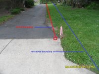
I was looking at some land in the VA mountains, composed of three odd shaped parcels (one looks like a cowboy hat), and the county GIS system out there had the owner names, parcels, and shapes totally scrambled up in a way that made no sense at all. I got the original surveys from the property owner, but have no way to visualize them on a full map to see how the three properties go together. If the county GIS site was even approximately right, it would be easy, but it's so out of whack it's completely misleading. God help the person who uses that information and doesn't attempt to sanity check things.
We'll go out there in the fall with the old paper surveys, find the corner pins, get modern GPS coordinates, and then put them on a map. That will be the first time I get a glimpse of the whole spread with the properties knit together. Having three separate plats of oddball shaped properties but no larger parcel map makes it a real challenge to know what we'd be buying.
We'll go out there in the fall with the old paper surveys, find the corner pins, get modern GPS coordinates, and then put them on a map. That will be the first time I get a glimpse of the whole spread with the properties knit together. Having three separate plats of oddball shaped properties but no larger parcel map makes it a real challenge to know what we'd be buying.
")
