DIY Bridge

   / DIY Bridge
  • Thread Starter
#61  
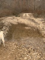
The creek only runs past my driveway after heavy rains. A lot of times it stops flowing on the surface and goes underground somewhere. My neighbor, who is a half mile upstream has water at his crossing many times when my crossing is dry.I’m in SE Missouri and the ground here is very rocky. Heavy rains/ rushing water is what causes the creek to change. No one really does any maintenance on the creek so we have washouts, gravel deposits, trees growing in the creek beds. All kinds of things.

i don’t expect the 2 36” pipes to handle all the water during the really heavy rain. At that point the bridge will be more of a spillway. I hope is to be able to cross the creek sooner and not have wait more than a day or so. I think you’re right about needing concrete/a footing on the down stream side. I don’t need any washouts or water getting under the crossing.
 
   / DIY Bridge
  • Thread Starter
#62  
The photo you posted looks like a very awkward situation to deal with.

Could you please explain what you think has caused the creek to move? Is there more runoff upstream from development or something? Did the existing creek bed fill up with material? Are there obstructions to flow downstream that didn't use to be there?

Would you happen to have an old photo of the area before this got this way?
The creek has filled will a lot of gravel over the years. The only development was when they moved the highway 3/4 miles closer to us, turned the two lanes into 4 lanes and knocked down some hills to fill in some valleys. Where my county road meets the highway, it’s 35 ft higher in elevation than it was before they moved the highway. Gee, I hope that didn’t sound bitter.
Thanks for commenting.
 
   / DIY Bridge
  • Thread Starter
#63  
(square not cubic, obviously)


Before consulting with authorities, find out if it's a protected watershed or some other designation that might limit your ability to perform construction.
If so, keep that in mind when doing what you need to do.
Been working with the County Commissioners. Not too many restrictions in this part of the country. Sometimes that’s good but sometimes it’s bad too.
 
   / DIY Bridge #64  
Well gary, you can probably tell that we love threads about water crossings here on TBN. Fun projects to achieve on your own property that usually require substantial tractor support.

But c’mon man, get us some real pics of the area and stream in question
 
   / DIY Bridge #65  
You probably know how to do this, but

Type in your property location in Google Maps
Click on Satellite View
Zoom in as appropriate
Click on Shift/Windows Key/S Key to get the Snip Tool (copies what you selected to your clipboard) - a very handy tool
Open Microsoft Paint and click Paste
Use Brushes and other drawing tools to map out your road, dry creek beds, etc.
Click on Shift/Windows Key/S Key to get the Snip Tool and select the image area you want to copy
Reply to this TBN thread, Right click and hit Paste
Select Insert on the lower left thumbnail
Click Post Reply

I takes longer to type this than it does to do the task!
 
Last edited:
   / DIY Bridge #66  
The creek has filled will a lot of gravel over the years. The only development was when they moved the highway 3/4 miles closer to us, turned the two lanes into 4 lanes and knocked down some hills to fill in some valleys. Where my county road meets the highway, it’s 35 ft higher in elevation than it was before they moved the highway. Gee, I hope that didn’t sound bitter.
Thanks for commenting.
It's important for you to know what has caused the stream to widen because it's too expensive to take guesses at what may be needed to get it back in its channel. If the gravel has filled in the channel, then the water has to spread out to compensate. It might also be that the county road work is causing water to run off faster than it did before the valleys were filled and the elevation was changed.

Years ago, there was a footbridge across the creek nearby. They didn't even try to cross the creek in a car when the water was up, but they could walk across the creek on the footbridge.
 
   / DIY Bridge
  • Thread Starter
#67  
T
Well gary, you can probably tell that we love threads about water crossings here on TBN. Fun projects to achieve on your own property that usually require substantial tractor support.

But c’mon man, get us some real pics of the area and stream in question
That was a real photo I posted. Here’s another from today. You can see the water is much lower now.
 

Attachments

  • 81E2597E-8901-431D-8083-161710D432B8.jpeg
    81E2597E-8901-431D-8083-161710D432B8.jpeg
    4 MB · Views: 153
   / DIY Bridge #68  
Are both photos looking down the same direction? Is that the county road at a T at the top of the picture?

1673148445279.png
 
   / DIY Bridge
  • Thread Starter
#69  
Yes, same direction, different times of the year. T at the end of the drive is county road.
It's important for you to know what has caused the stream to widen because it's too expensive to take guesses at what may be needed to get it back in its channel. If the gravel has filled in the channel, then the water has to spread out to compensate. It might also be that the county road work is causing water to run off faster than it did before the valleys were filled and the elevation was changed.

Years ago, there was a footbridge across the creek nearby. They didn't even try to cross the creek in a car when the water was up, but they could walk across the creek on the footbridge.
Last year my wife’s Toyota sat on the far side of the creek because of flooding, for over two months. Nice or something got in it a chew a bunch of wires. After a bad flood we can usually cross it after a day or two in our 4wd F250 or in waders. It flooded Tuesday night and I was able to cross in the F250 on Wednesday morning but the wife was afraid to try in our GMC pickup. We should be able to cross it now in the car. Sometimes we get a mound of gravel in the middle of the driveway that we can’t drive over or around.
 
   / DIY Bridge
  • Thread Starter
#70  
You probably know how to do this, but

Type in your property location in Google Maps
Click on Satellite View
Zoom in as appropriate
Click on Shift/Windows Key/S Key to get the Snip Tool (copies what you selected to your clipboard) - a very handy tool
Open Microsoft Paint and click Paste
Use Brushes and other drawing tools to map out your road, dry creek beds, etc.
Click on Shift/Windows Key/S Key to get the Snip Tool and select the image area you want to copy
Reply to this TBN thread, Right click and hit Paste
Select Insert on the lower left thumbnail
Click Post Reply

I takes longer to type this than it does to do the task!
Don’t have access to the computer right now but I used my phone and took some screenshots.
On this photo the yellow arrow shows points to the driveway. The blue arrows show the creek bed. You can see how the creek widens between the green and red arrows. That wide area in my drive is about 100. I think the dogleg is the biggest problem.
 

Attachments

  • B985F432-D1C3-47FA-B9AA-78B383616807.jpeg
    B985F432-D1C3-47FA-B9AA-78B383616807.jpeg
    1.7 MB · Views: 167

Tractor & Equipment Auctions

1996 Mack RD688S Day Cab T/A Tractor (A50860)
1996 Mack RD688S...
INOP/NON-RUNNING 2009 International 7600 Truck, VIN # 1HTWYAHT49J188295 (A48836)
INOP/NON-RUNNING...
2002 LEEBOY L7000T ASPHALT PAVER (A50458)
2002 LEEBOY L7000T...
2019 JOHN DEERE 325G SKID STEER (A50458)
2019 JOHN DEERE...
Apache 8800E Gasoline Generator (A50860)
Apache 8800E...
2016 John Deere 1775NT (A47164)
2016 John Deere...
 
Top